Follow us
  • Facebook
  • Instagram
  • Linkedin
  • Twitter
  • YouTube
en
  • Italian
  • English
Log in
OGS  Home
Search

Search

Main Menu

  • The institute
    • About Us

      • Vision, mission and values
      • History
      • Governance
      • Organisation
      • Documents
      • Onorificenze
    • Section of Oceanography

      • Physical Oceanography Group
      • Chemical and Biological Oceanography
      • Dynamics of Ecosystems and Computational Oceanography
      • Oceanographic Research Infrastructures and Laboratories
    • Section of 
Geophysics

      • Geology and Marine Geophysics
      • Applied and Exploration Geophysics
      • Geophysics Research Infrastructures and Laboratories
    • Center for Seismological Research

      • Seismology and Geodesy
      • Engineering Sesimology
      • Seismological Research Infrastructures and Laboratories
    • Centre for Management of Maritime Infrastructures

      • Ship Management Group
      • Naval infrastructures
  • Activities
    • Missions

      • Seas and Ocean
      • Earth processes
      • Natural risk
      • Polar areas
      • Open science
    • Research

      • Projects
      • Attuazione misure PNRR
      • Bulletin of Geophysics and Oceanography
      • National Group of Solid Earth Geophysics (GNGTS)
      • Networks, associations and consortia
      • Publications
    • Innovation

      • Applied research and services
      • Patents and inventions
      • Technology clusters
      • Industrial partners
    • Science for Society

      • External relations
      • Blue Skills
      • High Performance Computing Laboratory (HPC-TRES)
      • The Laboratory on Quantitative Sustainability (TLQS)
      • Communication and dissemination
      • Citizen science
      • Game based learning
      • Scientific and environmental diplomacy
  • Infrastructures
    • Maritime infrastructures

      • Research vessel Laura Bassi
      • Other boats
    • European Infrastructures

      • European contribution to the Argo programme (Euro-Argo ERIC)
      • European Carbon Dioxide Capture and Storage Laboratory Infrastructure (ECCSEL ERIC)
      • Partnership for Advanced Computing in Europe (PRACE)
      • Other European Infrastructures
    • Oceanographic Infrastructures

      • Gulf of Trieste Platform
      • Capo Granitola Observatory
      • Glider Station
      • National Oceanographic Data Centre (NODC)
      • Oceanographic Calibration and Metrology Center (CTMO)
      • Technological development and support for acquisitions in the field (TEC)
      • Collection of Marine Microorganisms (CoSMi)
      • Testing tank
      • Marine Chemistry and Biology Laboratories (BioMarine Lab)
      • Arctic marine observing system
    • Geophysical Infrastructures

      • Geophysical exploration infrastructure (GeoExp)
      • Aerial remote sensing facility (AiRS)
      • Borehole geophysical test site (PiTOP)
      • Geophysical data distribution facilities
      • Processing data center
      • Terrestrial Geology Lab
      • Laboratory of Marine Geology
      • Seismic software Lab (SEISLAB)
      • Laboratorio multi-sensor core logger
    • Seismological and Geodetic Infrastructures

      • Northeast Italy monitoring system (SMINO)
      • Antarctic Seismographic Argentinean Italian Network (ASAIN)
      • Everest Seismological Station (EvK2-CNR)
      • Facilities for distribution of seismic & geodetic data
      • Seismological Calibration Centre
      • Field seismic networks and Mobile Labs
      • Seismic monitoring of industrial activities
      • Geodetic Monitoring of Landslide Phenomena
      • Sensor Development Laboratory
  • People
    • Contacts
    • HR Excellence in Research
    • Support for foreign researchers
    • Mobility
    • Associated personnel
  • Work with us
    • Gare e appalti
    • Concorsi
    • Altre opportunità
    • Professional qualification
    • Occupational health and safety
  • News
    • News
    • Press release
    • Cinque per mille
    • Press Office
    • Press resources
  • Contacts
    • Offices
    • Institutional contacts
    • Public Relations Office
    • Data protection officer
    • Responsabile per la Transizione al Digitale

Glider Station

The OGS glider station is part of the international OceanGliders programme which aims to support marine research through the use of underwater drones.

Glider in acqua
  1. Home/
  2. Oceanographic Infrastructures/
  3. Glider Station

The OceanGliders programme aims at long-term observation of physical, biogeochemical and biological ocean processes and phenomena that are relevant to social applications, enables active coordination and strengthening of worldwide glider activity.

It contributes to current international ocean observation efforts for climate, ocean health and real-time services. The data provided by undersea drones are open access, available to all in real time and are used both in operational oceanography and in studies of processes or climate change. 

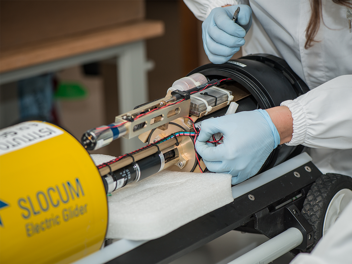
The OGS glider station aims in particular to study areas of the sea where certain processes occur, such as convective processes, where there is a transformation of water masses, especially in the Mediterranean Sea and in the vicinity of the Antarctic continent in the Southern Ocean. The station consists of 4 submarine drones and their piloting stations from where the gliders are controlled during missions, with experienced pilots able to tune and fly them along defined routes. These instruments measure the first 1000 meters of the water column, using only the variation of their attitude to reduce energy consumption to a minimum. At the end of the mission, which can last up to 3-4 months, they are retrieved for a battery change.

Organisation

OGS Contact
Elena Mauri
Info

Programma OceanGliders
www.oceangliders.org

Sito 
Mobile Autonomous Oceanographic Systems dell'OGS

Glider nella vasca navale
Manutenzione del glider

Organisation

OGS Contact
Elena Mauri
Info

Programma OceanGliders
www.oceangliders.org

Sito 
Mobile Autonomous Oceanographic Systems dell'OGS

Footer menu

Institute

  • About Us
  • Organisation
  • Section of Oceanography
  • Section of 
Geophysics
  • Center for Seismological Research
  • Centre for Management of Maritime Infrastructures

Activity

  • Missions
  • Research
  • Innovation
  • Science for Society
  • Real time data

Infrastructures

  • Maritime infrastructures
  • European Infrastructures
  • Oceanographic Infrastructures
  • Geophysical Infrastructures
  • Seismological and Geodetic Infrastructures

Other

  • People
  • Job opportunity
  • Tenders (IT)
  • Human Resource Strategy (HRS4R)
  • News
  • Intranet
OGS  Home

Contacts

National Institute of Oceanography and Applied Geophysics - OGS
Borgo Grotta Gigante 42/C
34010 - Sgonico ( TS ) - Italy
Tel.+39 040 21401
Fax.+39 040 327307

C.F./P.IVA : 00055590327
Posta Elettronica Certificata: ogs@pec.it

Institute links

  • Albo pretorio
  • Amministrazione trasparente
  • Accesso civico
  • Dichiarazione di accessibilità
  • Statistiche web
Follow us
  • Facebook
  • Instagram
  • Linkedin
  • Twitter
  • YouTube

Small prints

Useful links section

  • Privacy and cookie policy
  • Legal
  • Social media policy